
Air Density
In simple terms, density is the mass of anything - including air - divided by the volume it occupies.
In the metric system, which scientists use, we usually measure density in terms of kilograms per cubic meter.
The air's density depends on its temperature, its pressure and how much water vapor is in the air. We'll talk about dry air first, which means we'll be concerned only with temperature and pressure.
In addition to a basic discussion of air density, we will also describe the effects of lower air density – such as caused by going to high altitudes – on humans, how humidity affects air density – you might be surprised – and the affects of air density of aircraft, baseballs, and even racing cars.
The molecules of nitrogen, oxygen and other gases that make up air are moving around at incredible speeds, colliding with each other and all other objects. The higher the temperature, the faster the molecules are moving. As the air is heated, the molecules speed up, which means they push harder against their surroundings.
If the air is in a balloon, heating it will expand the balloon, cooling it will cause the balloon to shrink as the molecules slow down. If the heated air is surrounded by nothing but air, it will push the surrounding air aside. As a result, the amount of air in a particular "box" decreases when the air is heated if the air is free to escape from the box. In the free atmosphere, the air's density decreases as the air is heated.
Pressure has the opposite effect on air density.
Increasing the pressure increases the density. Think of what happens when you press down the handle of a bicycle pump. The air is compressed. The density increases as pressure increases.
Altitude and weather systems can change the air's pressure. As you go higher, the air's pressure decreases from around 1,000 millibars at sea level to 500 millibars at around 18,000 feet. At 100,000 feet above sea level the air's pressure is only about 10 millibars. Weather systems that bring higher or lower air pressure also affect the air's density, but not nearly as much as altitude.
We see that the air's density is lowest at a high elevation on a hot day when the atmospheric pressure is low, say in Denver when a storm is moving in on a hot day. The air's density is highest at low elevations when the pressure is high and the temperature is low, such as on a sunny but extremely cold, winter's day in Alaska.
The current Air Density at the N3UJJ Weather Station is 0.0725 lb/cu.ft at 7:23a on 08/02/16.

Barometric Pressure
The weight of the air that makes up our atmosphere exerts a pressure on the surface of the earth. This pressure is known as atmospheric pressure. Generally, the more air above an area, the higher the atmospheric pressure. This, in turn, means that atmospheric pressure changes with altitude. For example, atmospheric pressure is greater at sea-level than on a mountaintop. To compensate for this difference in pressure at different elevations, and to facilitate comparison between locations with different altitudes, meteorologists adjust atmospheric pressure so that it reflects what the pressure would be if measured at sea-level. This adjusted pressure is known as barometric pressure.
Barometric pressure changes with local weather conditions, making barometric pressure an important and useful weather forecasting tool. High pressure zones are generally associated with fair weather, while low pressure zones are generally associated with poor weather. For forecasting purposes, the absolute barometric pressure value is generally less important than the change in barometric pressure. In general, rising pressure indicates improving weather conditions, while falling pressure indicates deteriorating weather conditions.
The current Barometric pressure at the N3UJJ Weather Station is 30.021in and Rising Slowly at 7:23a on 08/02/16.
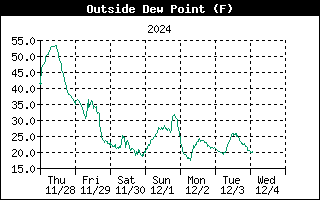
Dew Point
Dew-point is the temperature to which air must be cooled for saturation (100% relative humidity) to occur, providing there is no change in water content. The dew-point is an important measurement used to predict the formation of dew, frost, and fog. If dew-point and temperature are close together in the late afternoon when the air begins to turn colder, fog is likely during the night. Dew-point is also a good indicator of the air's actual water vapor content, unlike relative humidity, which takes the air's temperature into account. High dew-point indicates high vapor content; low dew-point indicates low vapor content. In addition a high dew-point indicates a better chance of rain and severe thunderstorms. You can even use dew-point to predict the minimum overnight temperature. Provided no new fronts are expected overnight and the afternoon Relative Humidity ³ 50%, the afternoon's dew-point gives you an idea of what minimum temperature to expect overnight, since the air is not likely to get colder than the dew-point anytime during the night.
The current Dew-point at the N3UJJ Weather Station is 73.2° at 7:23a on 08/02/16.

EMC (Equilibrium Moisture Content)
The moisture content of wood is directly related to the humidity and temperature of the surrounding air. The equilibrium moisture content (EMC) occurs when the wood has reached an equilibrium with its environment and is no longer gaining or losing moisture. Here is a calculator for computing the EMC of wood at or below the fiber saturation point (about 28% moisture content) given the temperature and relative humidity. This calculator uses average values and the results will be applicable to wood of any species for most practical purposes.
The current EMC at the N3UJJ Weather Station is 21.6% at 7:23a on 08/02/16.
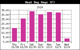
Degree-Days (Heating and Cooling)
Although degree-days are most commonly used in agriculture, they are also useful in building design and construction, and in fuel use evaluation. The construction industry uses heating degree-days to calculate the amount of heat necessary to keep a building, be it a house or a skyscraper, comfortable for occupation. Likewise, cooling degree-days are used to estimate the amount of heat that must be removed (through air-conditioning) to keep a structure comfortable. Just like growing degree-days, heating and cooling degree-days are based on departures from a base temperature. 65º F is almost always used as this base.
One heating degree-day is the amount of heat required to keep a structure at 65ºF when the outside temperature remains one degree below the 65ºF threshold for 24 hours. One heating degree-day is also the amount of heat required to keep that structure at 65ºF when the temperature remains 24ºF below that 65º threshold for 1 hour.
Likewise, one cooling degree-day is the amount of cooling required to keep a structure at 65ºF when the outside temperature remains one degree above the 65ºF threshold for 24 hours. One cooling degree-day is also the amount of cooling required to keep that structure at 65ºF when the temperature remains 24ºF above that 65º threshold for 1 hour.
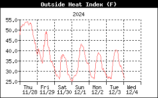
Heat Index
The Heat Index uses the temperature and the relative humidity to determine how hot the air actually "feels." When humidity is low, the apparent temperature will be lower than the air temperature, since perspiration evaporates rapidly to cool the body. However, when humidity is high (i.e., the air is saturated with water vapor) the apparent temperature "feels" higher than the actual air temperature, because perspiration evaporates more slowly.
The current Heat Index at the N3UJJ Weather Station is 78.2° at 7:23a on 08/02/16.
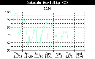
Humidity
Humidity itself simply refers to the amount of water vapor in the air. However, the amount of water vapor that the air can contain varies with air temperature and pressure. Relative humidity takes into account these factors and offers a humidity reading which reflects the amount of water vapor in the air as a percentage of the amount the air is capable of holding. Relative humidity, therefore, is not actually a measure of the amount of water vapor in the air, but a ratio of the air's water vapor content to its capacity. When we use the term humidity in the manual and on the screen, we mean relative humidity.
It is important to realize that relative humidity changes with temperature, pressure, and water vapor content. A parcel of air with a capacity for 10 g of water vapor which contains 4 g of water vapor, the relative humidity would be 40%. Adding 2 g more water vapor (for a total of 6 g) would change the humidity to 60%. If that same parcel of air is then warmed so that it has a capacity for 20 g of water vapor, the relative humidity drops to 30% even though water vapor content does not change.
Relative humidity is an important factor in determining the amount of evaporation from plants and wet surfaces since warm air with low humidity has a large capacity to absorb extra water vapor.
The current humidity at the N3UJJ Weather Station is 95% at 7:23a on 08/02/16.

Rain
The Weather Station incorporates a tipping-bucket rain collector that measures 0.01" for each tip of the bucket. The station logs rain data in inch units. Four separate variables track rain totals: "rain storm", "daily rain", "monthly rain", and "yearly rain". Rain rate calculations are based on the interval of time between each bucket tip, which is each 0.01" rainfall increment.
The current rain at the N3UJJ Weather Station is 0.01 in at 7:23a on 08/02/16.
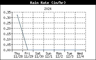
Rain Rate
The rain rate is calculated by measuring the time interval between each rainfall increment. When there is rainfall within the archive period, the highest measured value is reported. When no rainfall occurs, the rain rate will slowly decay based on the elapse time since the last measured rainfall.
The current rain at the N3UJJ Weather Station is 0.01 in at 7:23a on 08/02/16.
Storm Rain
Storm rain displays the rain total of the last rain event. The Weather Station takes .02" to begin a rain event and 24 HOURS WITHOUT RAIN to end a rain event.

THW Index (Temperature Humidity Wind)
The THW Index uses humidity, temperature and wind to calculate an apparent temperature that incorporates the cooling effects of wind on our perception of temperature.
The current THW Index at the N3UJJ Weather Station is
78.2° at 7:23a on 08/02/16.
THSW Index (Temperature/Humidity/Sun/Wind)
The THSW Index uses humidity and temperature like the Heat Index, but also includes the heating effects of sunshine and the cooling effects of wind (like Wind chill) to calculate an apparent temperature of what it "feels" like out in the sun.
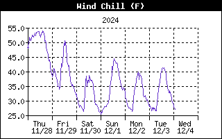
Wind Chill
Wind chill takes into account how the speed of the wind affects our perception of air temperature. Your body warms the surrounding air molecules by transferring heat from your skin. If there's no air movement, this insulating layer of warm air molecules stays next to your body and offers some protection from cooler air molecules. Wind disperses this layer of warm air, causing the air temperature to "feel" colder. The faster the wind blows, the quicker the layer of warm air is dispersed, and the colder you feel. Above 76.7ºF (24.8ºC), wind movement has no effect on the apparent temperature.
The current Wind chill at the N3UJJ Weather Station is
74.7° at 7:23a on 08/02/16.
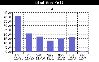
Wind Run
Wind Run is calculated by multiplying the wind speed by the measurement period and summing over time. If the wind speed was a constant 10 miles per hour for three hours, the wind run would equal 30 miles.